 See a Recording of a CHRSE Webinar on Hyperspectral UAV Flights over Hops in Bavaria
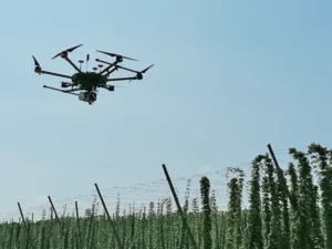
Learn about an ongoing mission flying lightweight UAVs with hyperspectral-imaging systems over hops fields in Bavaria. Two webinars were hosted in order to accommodate attendees worldwide, March 12th at 9am US EDT / 2pm CET or 1pm US EDT / US 10am PDT. You may see recordings of either, or choose to see a single recording that combines the best presentations and both sets of Q&A (recommended).
Hops are green cone-shaped flowers of the Humulus lupulus plant. They are a climbing perennial with tiny yellow pods or glands called lupulin inside each cone—the source of bitterness, aroma, and flavor in beer.
The panelists were Francesco Beccari, Headwall EMEA & India Sales Manager for Remote Sensing; Johannes Seidl-Schulz, geo-konzept GmbH Produktspezialist Fernerkundung; Christoph Schimmer, geo-konzept GmbH Produktspezialist Fernerkundung; Florian Weiss, Researcher at Bayerische Landesanstalt fur Landwirtschaft; and Daniel Hajek, Research Student at Katholische Universitat Eichstatt.
The Center for Hyperspectral Remote Sensing Europe (CHRSE) was founded by Headwall and geo-konzept to support the implementation and utilization of hyperspectral imaging technology combined with other sensor technology (e.g., LiDAR and GPS) with a focus on agriculture, environmental monitoring, mining, and infrastructure inspection applications


View a Recording featuring the Webinar and both sets of Q&A (recommended)
View the Recording of the First Webinar, scheduled for EMEA viewers
View the Recording of the Second Webinar, scheduled for US-Canada-LatAm viewers
(may require free registration)